
| Added | Wed, 03/03/2021 |
| Источники | |
| Дата публикации | Mon, 01/03/2021
|
| Версии |
Erosion or cryoturbation? What caused the mysterious broken patterns on the soil surface in the Arctic zone of Siberia? And why do they disappear along the riverbanks? Scientists offer their own versions in search of an answer to this question.
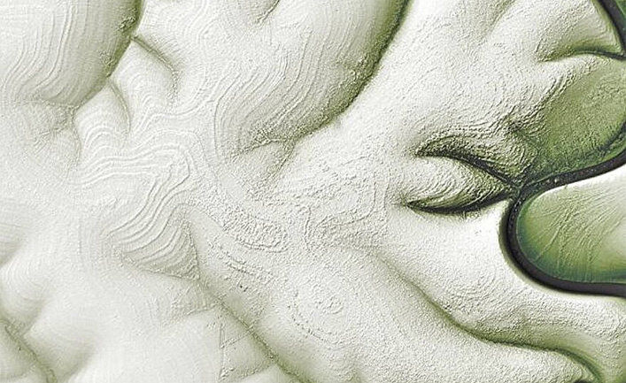
A series of satellite images of the northern part of Siberia, taken by NASA, captures a very unusual landscape. From orbit, you can see that the surface is marked with broken patterns, as well as dark and light wavy lines. The unusual nature of this phenomenon, observed in the Arctic zone of Siberia, baffles scientists trying to explain it.
Images captured by Landsat 8 show both banks of the Markha River in northeastern Siberia. The area has been monitored for several years, and the landscape is captured at different times of the year. This week, the NASA Earth Observatory website published some of these images, which attracted attention by the unusual nature of the captured terrain.
Scientists can not exactly name the reasons why these color patterns formed on earth, which become more contrasting in winter. Some experts believe that it's all about frozen soil.
According to NASA, this part of the Central Siberian Plateau, located in the Arctic region, 90 percent of the time is covered with permafrost, which thaws briefly. According to an article published in the journal Science in 2003, when the melted areas freeze again, they form strange undulating and striped patterns, known as "patterned soils".
However, this explanation does not fully describe the phenomenon observed in the region, since in the case of other examples of patterned soils, smaller lines are usually formed on the surface than in this case.
Meanwhile, geomorphologists offer a different explanation for these multi-colored lines, based on the type of soil in the region. The fact is that in such cold regions there is a phenomenon known as "Arctic soils". The first two meters of the surface are covered with permafrost, and the shade of the layers — dark or light-depends on the volume of organic and mineral material and the sediments contained.
As the soil thaws and refreezes, the layers are disturbed and vertically mixed in a process known as cryoturbation. When thawing and freezing of the soil during the year, the layers can form a kind of striped pattern. Different types of tundra vegetation (lichens, small shrubs, and moss) can grow on different layers of this Arctic soil, emphasizing the lines observed from orbit. However, this hypothesis has not yet been tested on a large scale.
Another likely cause is erosion. Thomas Crafford, a geologist with the US Geological Survey, suggested on the NASA Earth Observatory website that the observed bands are similar to a pattern of sedimentary rocks, known among scientists as "layer cake geology".
Such patterns are formed when pieces of sedimentary rock break off and gather in heaps when snow or rain falls. According to Crafford, this process can reveal deposits that resemble layers of cake, where darker stripes correspond to steeper territories and lighter stripes correspond to flatter ones.
Judging by satellite images, this type of distribution of sedimentary layers is more noticeable in winter, when snow is lying on flatter areas, which makes them visually lighter.
As you approach the river, the pattern gradually disappears.
"The fact is that after millions of years of erosion along the coasts, sediments accumulate more evenly," says Crafford.
According to Crafford, the pattern disappears on the banks of the river, as there, over millions of years of erosion, the sediments formed more uniform layers.
Новости со схожими версиями
A dragon pattern appeared in the Taklamakan Desert in China after a snowfall
Scientists have revealed the secret of unusual "honeycomb patterns" in salt deserts
Scientists have found a possible explanation for the "magic circles" in the fields in Namibia

Log in or register to post comments